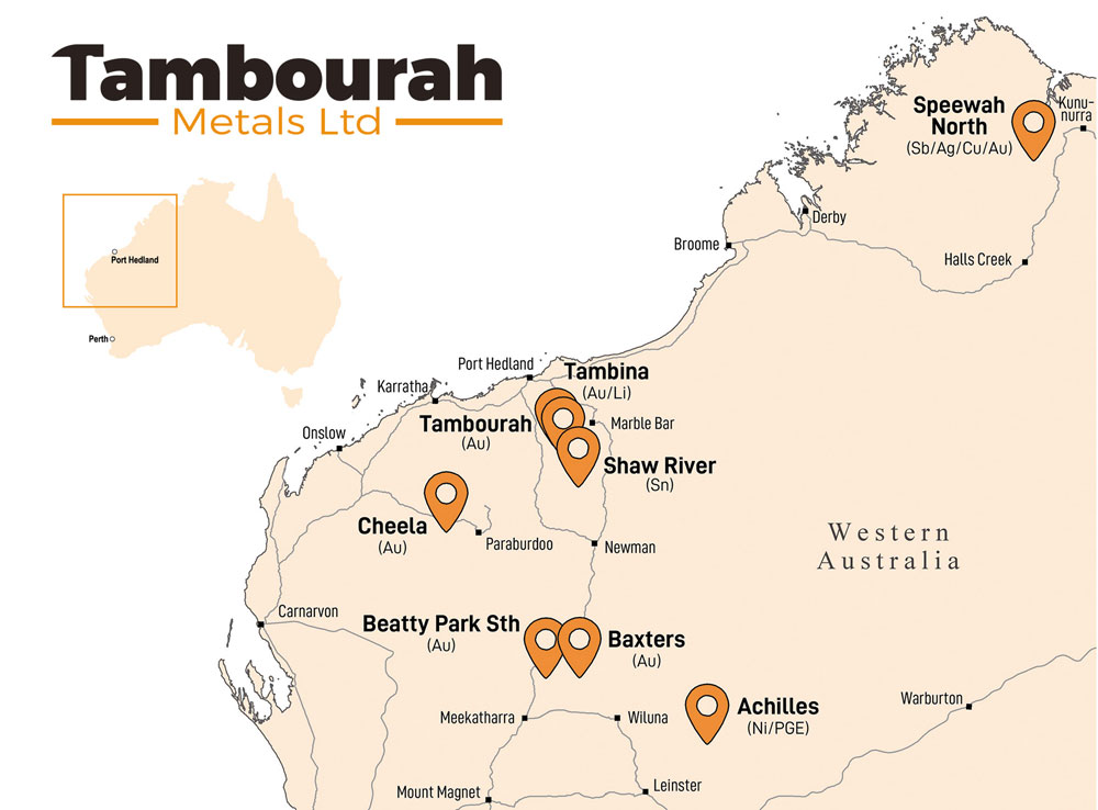
Tambourah Metals is exploring for Gold at Beatty Park Sth within the Bryah Basin in the Murchison region and the Tambourah goldfield in the Pilbara. Since listing the Company has extended the portfolio to include additional critical mineral projects at Shaw River and Speewah Nth and additional gold prospects in the Bryah Basin that comprise the 467km² Bryah Gold Project. Tambourah aims to cost-effectively acquire strategic positions in regions of known endowment and production.
Scroll for more or visit our Announcements page for latest updates.
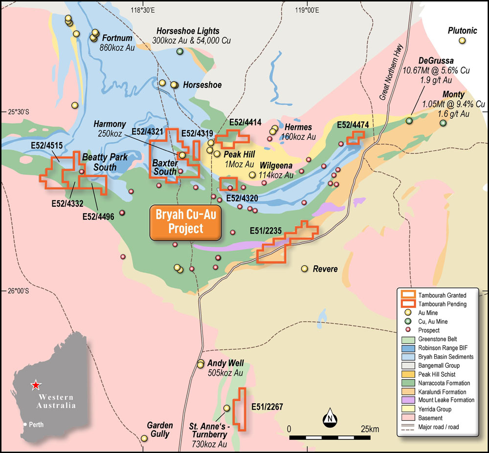
Beatty Park Sth is 160km north of Meekatharra, Western Australia. Gold mineralisation occurs near the upper contact of the Narracoota Formation with the overlying Horseshoe Formation. Elsewhere in the Bryah Basin, this contact hosts significant deposits of gold and base metals (e.g. Harmony, Fortnum, Horseshoe Lights). First-pass aircore drilling yielded highly promising gold results and evidence of extensive hydrothermal alteration that is commonly associated with shear-related gold mineralisation. Beatty Park Sth is a high priority for follow up exploration.
(ASX announcement 1 October 2025)
The Baxter Sth prospect represents an exciting, incompletely tested gold target within a NW trending structural corridor that parallels the Harmony structure. Tambourah Metals believes the historic (1990s) RC drilling program orientation was not optimal and missed the primary Ravelstone-Narracoota contact target. At the Harmony deposit, 4km to the north, mineralised veins within sediments of the Ravelstone Fm occur adjacent to the contact with the Narracoota Fm. However, the bulk of the gold mineralisation at Harmony is hosted within the Narracoota Fm that is the target of Tambourah’s planned drilling at Baxter Sth.
The Tambourah Gold Project is located 85km southwest of Marble Bar in the East Pilbara district of Western Australia. The project covers an area of approximately 1520 ha. Gold mining commenced in the 1890s at the Tambourah and Western Shaw mining centres. The bulk of the recorded production came from Western Chief and World’s Fair gold mines. Total gold production from the Tambourah mining centre is reported as 163.2kg (5,247oz) (pg.131, TMB Prospectus Aug 12th, 2021) equating to a 27.35 g/t head grade. Tambourah is systematically targeting the multiple historic shallow workings with RC and diamond drilling to confirm historic lode-style high-grade gold mineralisation and identify areas with potential to host a resource. Initially, a model of the Tambourah King mineralisation is being created, with the aim of developing a preliminary resource estimate for the prospect.
(ASX announcement 11 September 2025)
The Tambina Gold Project is located approximately 75km southwest of Marble Bar in Western Australia and 17km north of the Tambourah Gold Project. The hosting geological sequence includes rocks of the lower Fortescue Group that are folded into a south-southeast trending basin with approximate dimensions of 7.5km long by 1.5km wide. Multiple gold in soil anomalies (up to 500m in length) have been identified in association with the target conglomerate units. Historic bulk surface samples and trench samples of weathered Fe-oxide conglomerate units reported multiple anomalous sites of greater than 1g/t Au, including grades of up to 62g/t Au and visible gold in panned concentrates.
Cheela is located 70km northwest of Paraburdoo and adjacent to the Paraburdoo-Nanutarra Road. The Cheela Project includes 22.5km of the crustal-scale Nanjilgardy Fault, a major northwest trending fault system that is believed to be the conduit for mineralisation at the +1Moz Au Paulsens and Mt Olympus gold deposits and the 22,000 oz Electric Dingo deposit located 5km southeast along strike from the Cheela Prospect. Mineralisation at Cheela is hosted in a weathered sequence comprising interlayered dolomitic shale, siltstone and sandstone with associated quartz veining.
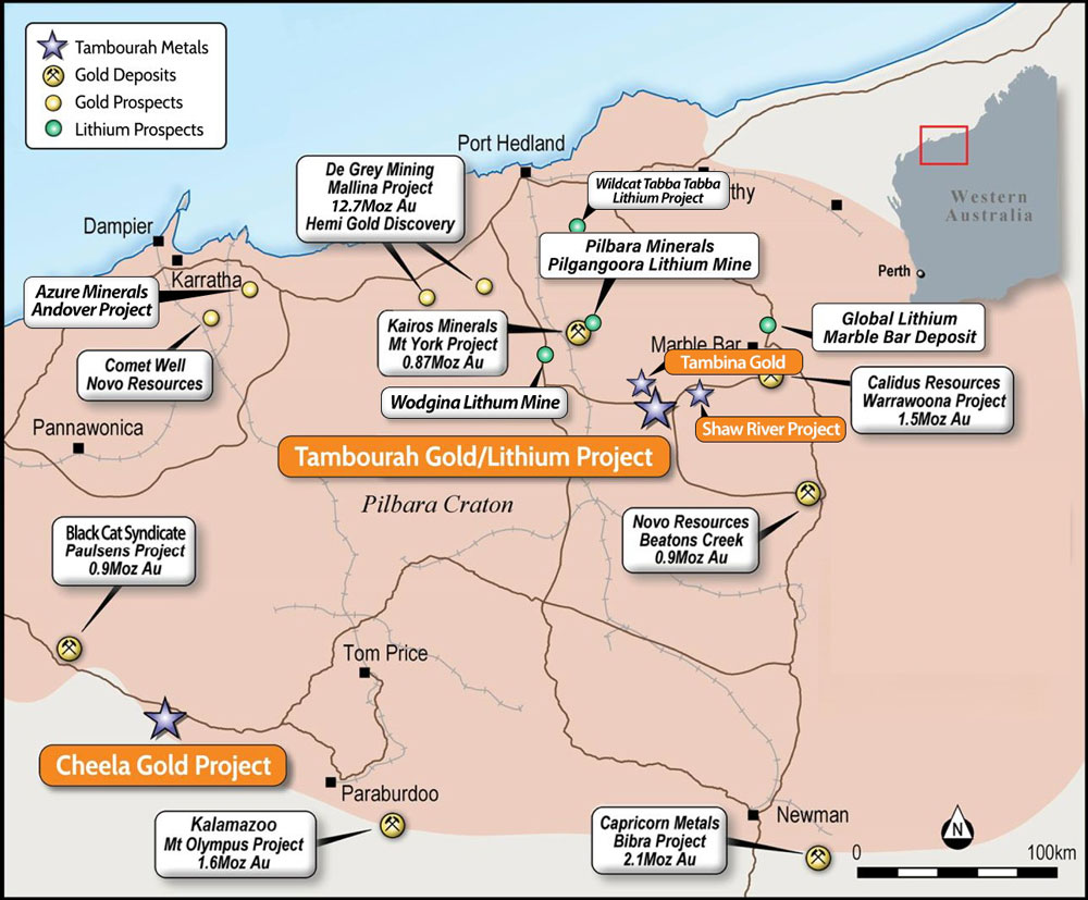
The Shaw River project is located 180km southeast of Port Hedland, Western Australia. The Shaw River tenement contains the historic Shaw River tin field, mined extensively for alluvial tin deposits up to 1975. It lies on the southern margin of the Cooglegong Monzogranite, a “tin granite” (Blockley, 1980) and part of the regionally important Split Rocks Supersuite associated with major pegmatite-hosted lithium deposits in the Pilbara. Analysis and investigation of the source of tin and the potential for associated critical minerals, including REE, is on-going.
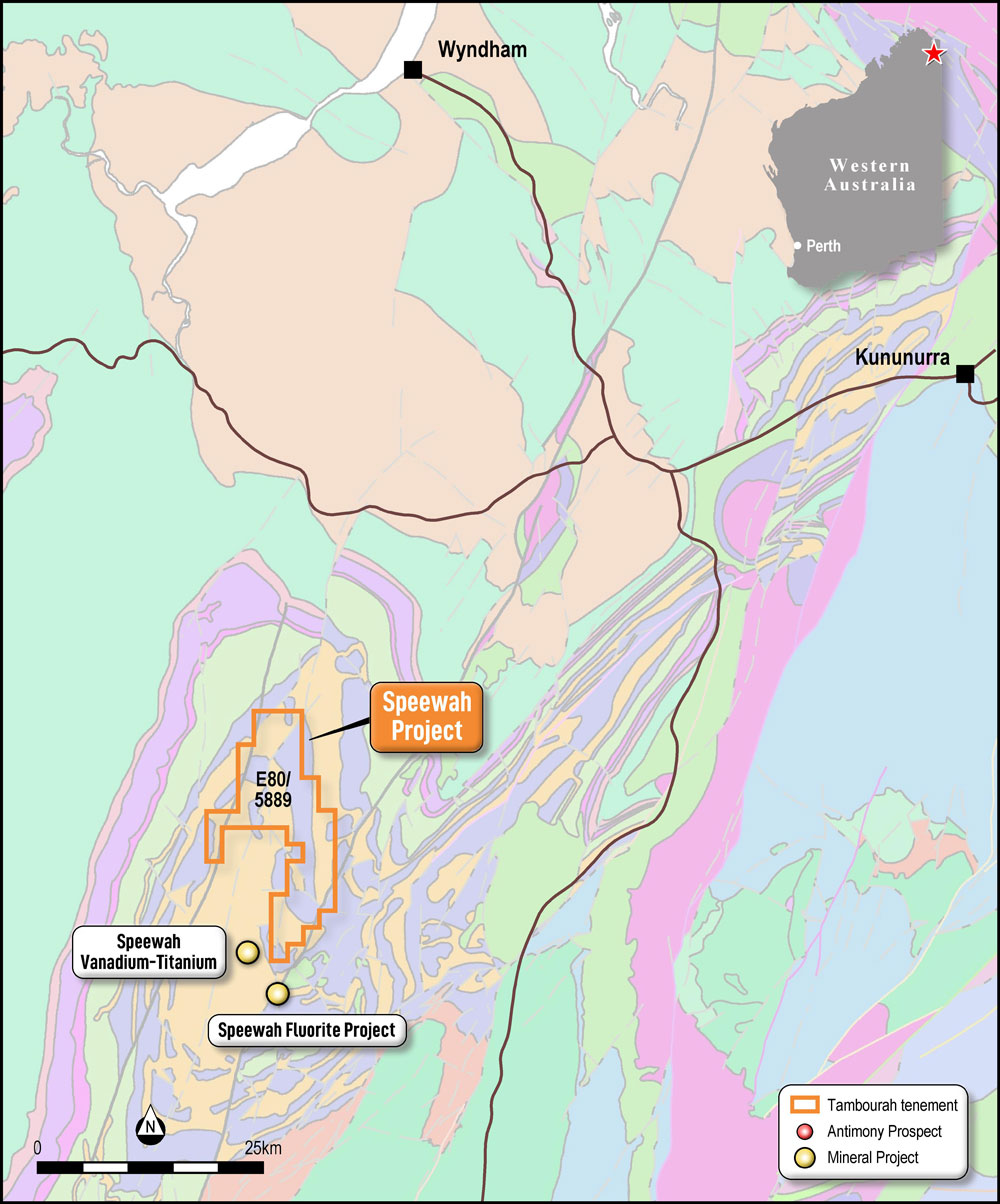
The Company has an 80% interest in the Speewah Nth project, located 110km southwest of the town of Kununurra in the Kimberley region of Western Australia. The tenement is accessed via the Victoria and Great Northern Highways. The project covers an area of 181 sq.km and is located over the northern half of the Speewah Dome, a domal structure comprised of sediments of the Speewah Group intruded by a large composite sill, the Hart Dolerite. Major northeast and north-trending faults cutting Speewah Group sediments host the important Speewah Fluorite deposit whilst the layered gabbroic sill of the Hart Dolerite hosts a large orthomagmatic V-Ti ± PGE deposit. These structures also host extensive veining, brecciation and alteration within the Speewah Nth project and have been explored for gold and copper in the past. Historic exploration has noted significant antimony and silver in rock sampling and Tambourah has commenced systematic exploration over the areas where anomalous values of these critical minerals have been recorded. Infrastructure and development in the Speewah area is increasing with the planned development of the Speewah Fluorite deposit (owned by Tivan Limited) 4km south of Tambourah’s project. The development of the Speewah Fluorite deposit has been granted major project status by the Federal government.
(ASX announcement 28 October 2025)